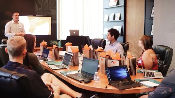
On June 22, Anthbot used Spoga+Gafa 2026 in Cologne to pitch a robotic mower navigation stack that does not bet on one sensor winning every argument.
The company’s new HoloSense system will appear in the Anthbot M5 Pro and Anthbot M9 Pro, combining 360° LiDAR, RTK/NetRTK positioning, and AI Vision for a claimed positioning accuracy of up to 1 cm, according to Notebookcheck. That matters because real gardens are messy: tree shade, narrow passages, patio edges, walls, and temporary obstacles can expose the limits of simpler robotic lawn mowers.
Anthbot’s pitch is not that LiDAR, RTK, or cameras are new. They are not. The notable part is the combination. Notebookcheck says RTK-plus-camera and LiDAR-plus-camera setups are already common, but using RTK/NetRTK and LiDAR at the same time remains unusual in robotic mowers.
June 22 in Cologne: Anthbot makes navigation the selling point
Anthbot unveiled HoloSense at Spoga+Gafa 2026, Europe’s garden and outdoor living trade fair, which ran from June 22–24 at Koelnmesse in Cologne. The system made its trade fair debut in the M5 Pro and M9 Pro robotic mowers.
The company says the M Pro Series constantly samples three types of data:
- Geometric data: captured by LiDAR.
- GPS/location data: supported by RTK/NetRTK.
- Visual data: interpreted through cameras and AI Vision.
Anthbot’s own description frames HoloSense as a “fusion-navigation architecture,” not a single navigation feature bolted onto an existing mower. In its announcement, the company said the system is designed to move beyond “mainstream solutions that rely mainly on RTK, vision, or basic RTK + vision setups.”
“HoloSense reflects our vision for the next generation of robotic lawn care,” said Gavin Guo, CEO at ANTHBOT. “By combining multiple navigation and sensing technologies into one platform, we aim to deliver a more reliable and intelligent mowing experience for homeowners.”
The immediate promise is simple: better positioning when a garden does not behave like a flat, open test lawn.
What HoloSense adds to the Anthbot M5 Pro and M9 Pro
HoloSense is Anthbot’s multi-sensor navigation system for the M5 Pro and M9 Pro robotic lawn mowers. Its job is to help the mower understand where it is, what surrounds it, and how to continue mowing when one source of information becomes unreliable.
Here is the stack in plain terms:
| HoloSense component | Main role in navigation | Where it can help |
|---|---|---|
| 360° LiDAR | Builds a local map from distance measurements | Walls, trees, edges, nearby structures |
| RTK/NetRTK | Improves satellite-based positioning accuracy | Open lawns, route consistency, boundary positioning |
| AI Vision | Interprets visual scenes through cameras | Lawn edges, pathways, objects, visual context |
Older robotic mowers often depend on buried or laid perimeter wires. Many newer wire-free models lean on RTK, cameras, LiDAR, or combinations of two systems. Anthbot’s Pro approach is to make the mower cross-check all three categories at once.
That cross-checking is the core claim. If RTK weakens under tree cover, LiDAR and camera data may still provide context. If LiDAR has fewer useful landmarks in an open lawn, RTK may carry more of the load. If visual data is ambiguous, geometry and positioning data may help constrain the mower’s decision.
Notebookcheck reports that Anthbot has not yet disclosed additional specifications for the Pro models. The publication expects the Pro versions to be otherwise close to the existing Anthbot M5 and Anthbot M9. On that basis, it expects the M5 Pro to target lawns of up to about 500 square meters, while the M9 Pro should handle up to 1,000 square meters.
How LiDAR, RTK/NetRTK, and AI Vision work together
LiDAR gives the mower a local sense of shape. It sends out laser pulses, measures distance, and builds a picture of nearby geometry. For a robotic lawn mower, that can mean identifying the edge of a wall, the position of a tree trunk, or the shape of a narrow passage.
RTK improves satellite positioning by using correction data to reduce location error. NetRTK extends that idea through network-based correction services. Anthbot says HoloSense uses RTK/NetRTK positioning as one of the three pillars of the system.
AI Vision supplies the visual layer. Cameras can help interpret scenes that pure geometry or satellite position cannot fully explain. Anthbot specifically says the M Pro Series uses cameras alongside LiDAR and RTK/NetRTK, with the system cross-validating geometric, visual, and GPS data.
This is sensor fusion. The mower does not treat one sensor as gospel. It compares inputs and uses overlap to reduce uncertainty.
A useful way to read Anthbot’s claim is not “the mower always knows everything.” It is more restrained: the mower should have more ways to recover when one navigation channel degrades. That is the difference between a single point of failure and a system with redundancy.
Anthbot says HoloSense is intended to work across “wide-open turf, deep tree shade, tricky corners” and claims the M5 Pro/M9 Pro “never loses its way.” That is a strong marketing claim. Independent testing will need to show how it behaves across real gardens, changing light, weather, and imperfect setup.
A 500-square-meter garden scenario: where the three signals would matter
Consider a 500-square-meter suburban garden — the scale Notebookcheck expects for the M5 Pro — with a main lawn, a tree canopy, a narrow passage to a side yard, flower beds, a patio edge, and a few objects left on the grass.
This is scenario analysis, not a reported Anthbot field test.
In the open section, RTK/NetRTK would likely do much of the positioning work. The mower has a clearer view of the sky, so satellite correction data should be more useful for holding a route and staying inside its mapped area.
Under the tree canopy, satellite positioning may become less dependable. That is where 360° LiDAR becomes more important. Nearby trunks, walls, and other fixed shapes can give the mower local reference points. AI Vision can add visual context around grass edges, paths, and objects.
In a narrow passage, LiDAR’s geometry could help the mower understand the corridor shape. Around the patio edge, AI Vision may help distinguish lawn from hard surface, while RTK/NetRTK keeps the broader map position anchored.
The point is not that HoloSense makes every garden easy. Setup quality, software tuning, lighting, rain, mud, dense foliage, and network availability can still matter. The better claim is that Anthbot is trying to reduce the number of conditions where the mower has only one weak signal to depend on.
The trade-off after the demo: more sensors mean more variables
A three-sensor mower can improve resilience, but it also adds complexity. More sensors mean more hardware to calibrate, more software decisions, and more dependence on how well the mower blends conflicting inputs.
There are also practical questions buyers should not ignore:
- Price: Notebookcheck says the Anthbot M9 Pro is already listed on Amazon at €1,699, but adds that this is not the final price and is expected to be significantly lower.
- Availability: Notebookcheck says it remains unclear when the M5 Pro and M9 Pro will officially go on sale.
- Connectivity: NetRTK implies network-based correction, so coverage and service reliability may affect the experience.
- Privacy: AI Vision means cameras are part of the navigation stack. Buyers should check how mapping and visual data are handled once final product details arrive.
- Maintenance: LiDAR and camera systems can be affected by dirt, water, glare, or physical obstruction.
This is the same basic buyer discipline that applies across connected hardware: headline specs are not the same as lived reliability. We have seen that in very different categories too, from discount-driven decisions around AirPods Pro 3 pricing to feature-versus-cost trade-offs in wearables like the Amazfit Helio Strap Pro.
The next decision point: final specs, price, and independent mowing tests
The M5 Pro and M9 Pro make the most sense on paper for lawns where simple navigation is likely to struggle: larger areas, multiple zones, tree cover, tight paths, complex edges, or owners who want to avoid perimeter wires.
Before buying, the useful questions are concrete:
- Lawn size: Does the expected 500 square meter M5 Pro class or 1,000 square meter M9 Pro class match the property?
- Sky visibility: Are there trees, walls, or structures that could weaken satellite positioning?
- Network access: Is the garden covered well enough for any NetRTK-dependent features?
- Mapping workflow: How easy is setup in the app, and how much manual correction is needed?
- Obstacle behavior: How does the mower react to temporary objects in independent reviews?
- Core specs: Battery life, slope rating, cutting width, warranty, and software update policy still matter.
Anthbot has made a technically interesting move by combining LiDAR, RTK/NetRTK, and AI Vision in one robotic mower navigation system. The next thing to watch is whether final retail pricing, full specifications, and real-world reviews support the 1 cm positioning claim outside a trade-fair demo area.
Key Takeaways
- Anthbot is betting that combining LiDAR, RTK/NetRTK, and AI Vision can make robotic mowers more reliable in messy real-world gardens.
- The claimed accuracy of up to 1 cm could help with narrow passages, patio edges, walls, shade, and temporary obstacles.
- If the M5 Pro and M9 Pro deliver on the pitch, sensor fusion may become a bigger selling point in premium robotic lawn care.