Introduction: Understanding Monday's Severe Weather Threat in Minnesota
Minnesota residents are bracing for a significant severe weather event on Monday, as meteorologists have issued warnings about the potential for tornadoes, baseball-sized hail, and damaging winds across the state. The forecast has prompted heightened alert levels, with local weather authorities urging vigilance and preparedness for what could be a volatile evening and overnight period. Monday’s conditions represent a classic setup for severe storms, with the possibility of rapid changes and unpredictable developments. The hazards posed—ranging from tornado touchdowns to large hailstones capable of causing substantial damage—underscore the importance of staying informed and having a safety plan in place. As the state faces this heightened risk, understanding the meteorological drivers and the types of threats involved is vital for every Minnesotan looking to protect themselves, their families, and their property [Source: Source].
Meteorological Conditions Leading to Severe Weather
The severe weather threat in Minnesota on Monday is rooted in a convergence of meteorological factors, making the atmosphere ripe for powerful storms. Foremost among these are rising temperatures and dew points, which indicate a surge of moisture moving northward into the region. As temperatures climb overnight, so do dew points, contributing to increased humidity and the latent energy needed for storm formation [Source: Source].
Atmospheric instability is a key ingredient. Instability occurs when warm, moist air at the surface meets cooler, dry air aloft, creating a situation where air parcels can rise rapidly. This vertical movement is the engine behind thunderstorm development, and when instability is high, storms can grow quickly and reach severe levels.
Wind shear, the change in wind speed and direction with altitude, further enhances the threat. Wind shear is crucial for tornado formation because it allows storms to develop rotating updrafts, which can eventually produce tornadoes. The interplay between instability and wind shear is what meteorologists are monitoring closely, as these dynamics often dictate whether storms remain ordinary or escalate into supercells—the type of thunderstorm most commonly associated with tornadoes and large hail.
Weather fronts and pressure systems also play a decisive role in triggering severe weather. A warm front lifting through Minnesota brings in the moisture and warmth needed for storms, while a trailing cold front can provide the spark that initiates thunderstorm development. Low-pressure systems add lift, helping to force air upward and fuel storm growth. Together, these factors create an environment where severe storms are not only possible but likely, especially as evening approaches and atmospheric conditions peak [Source: Source].
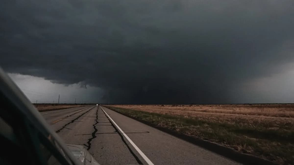
Types of Severe Weather Expected: Tornadoes, Hail, and Damaging Winds
Monday’s forecast highlights three primary threats: tornadoes, baseball-sized hail, and damaging winds. Each poses distinct dangers and warrants careful attention.
Tornadoes are violently rotating columns of air that extend from the base of a thunderstorm to the ground. They form when wind shear and instability coalesce, typically within supercell thunderstorms. Tornadoes can cause catastrophic damage in a matter of seconds, uprooting trees, destroying buildings, and posing life-threatening risks to anyone caught in their path. The current forecast indicates conditions are favorable for tornado development, with meteorologists warning residents to be prepared for rapid changes and possible tornado watches or warnings throughout the evening [Source: Source].
Hail, particularly hailstones as large as baseballs, is a hallmark of intense thunderstorms. Hail forms when strong updrafts carry water droplets high into the storm, where they freeze and grow until gravity pulls them down. Baseball-sized hail can shatter windows, dent vehicles, and cause serious injuries to people and animals caught outside. The risk of such large hail is notable because it suggests storms will be particularly powerful, with significant updraft strength and the potential for widespread property damage [Source: Source].
Damaging winds often accompany severe thunderstorms, sometimes reaching speeds above 60 mph. These winds can topple trees, power lines, and structures, creating hazards for drivers, homeowners, and emergency responders. Unlike tornadoes, damaging winds can affect larger areas, making them a pervasive threat during widespread severe weather outbreaks. The combination of wind, hail, and tornadic activity means that Minnesota communities must prepare for multiple hazards simultaneously, with the potential for power outages, road closures, and other disruptions [Source: Source].
Warnings and Alerts: What the First Alert Weather Day Means
Monday’s severe weather risk has prompted local meteorologists to designate it as a First Alert Weather Day, a term used to signal heightened risk and the need for residents to be on guard. The designation is reserved for situations where the probability of severe storms, tornadoes, or other extreme weather events is significantly elevated, warranting extra attention from the public [Source: Source].
Weather services communicate these risks through a variety of channels: television broadcasts, radio alerts, social media updates, and smartphone notifications. When severe weather approaches, forecasters may issue watches (which mean conditions are favorable for storms) or warnings (which mean storms are imminent or occurring). Residents should pay close attention to these alerts, as they offer the most timely and accurate information.
During a First Alert Weather Day, experts recommend having multiple ways to receive warnings, such as NOAA weather radios and smartphone apps with push notifications. It’s also wise to have a plan for quick sheltering and to avoid travel during the periods of highest risk. The goal is to ensure everyone is informed and ready to act if severe weather threatens their area [Source: Source].
Safety Tips and Preparedness for Residents
Preparation is essential when severe weather is forecast. Here are key safety tips for Minnesota residents:
Develop an emergency plan: Identify safe locations in your home, such as a basement or interior room away from windows, where you can shelter during tornadoes or hailstorms. Make sure all family members know the plan and practice it periodically.
Sheltering during tornadoes: If a tornado warning is issued, immediately move to your designated safe spot. Avoid windows, and cover yourself with sturdy materials such as mattresses or heavy blankets. If you’re outdoors and can’t get to shelter, lie flat in a low-lying area and protect your head [Source: Source].
Hailstorm safety: When hail threatens, stay indoors and away from windows. If you’re driving, pull over and seek shelter in a sturdy building. Large hail can shatter glass and cause injuries, so minimizing exposure is crucial.
Monitor weather updates: Keep a battery-powered NOAA weather radio and ensure your phone is charged to receive alerts. Follow local news and meteorological services for real-time updates, as conditions can change rapidly.
Emergency supplies: Prepare a kit with essentials such as water, food, flashlights, batteries, and first-aid supplies. This ensures you’re ready for power outages or disruptions that often follow severe storms.
By following these guidelines, residents can reduce their risk and respond effectively when severe weather strikes [Source: Source].
Conclusion: Staying Informed and Prepared Amid Severe Weather Risks
Minnesota faces a significant severe weather threat on Monday, with the potential for tornadoes, baseball-sized hail, and damaging winds demanding heightened vigilance from all residents. Understanding the meteorological conditions fueling these storms and recognizing the risks posed by each hazard is the first step in staying safe. As weather services issue alerts and designate this as a First Alert Weather Day, it’s crucial for Minnesotans to develop emergency plans, shelter appropriately, and monitor updates closely. Proactive safety measures and timely information can make all the difference, helping communities weather the storm and minimize harm. Stay informed, stay prepared, and heed official warnings to ensure your safety and the safety of those around you [Source: Source].